Thursday, November 5, 2020

Bethlehem views from the Studio of the Eastern Illustrating Co

Back over the summer I was obsessed with postcards from the Eastern Illustrating Company of Belfast, Maine and kept meaning to write up a blog post.  Then I got distracted by the 1898 assessment roll.  

Now, I am back to it. First, a little background, then a whole bunch of photos that you will spend hours poring over.  Believe me, I have.

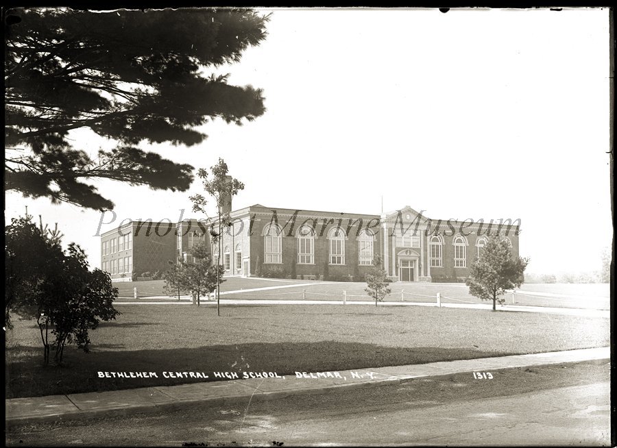
So, I have seen the logo above on several postcards in the town's historic photo collection.  It got me to wondering about what a company in Maine had to do with Bethlehem.  Googling around led me to the website of the Penobscot Marine Museum and the most astonishing collection of "real photo" postcards and the glass plate negatives they were created from.  Basically, from 1909 to 1947, the Eastern Illustrating Company sent photographers all over the northeast to take pictures of notable local sites that they then turned into postcards.  Go to their website and read all about it. 

https://penobscotmarinemuseum.org/eastern-illustrating-publishing-company/

In searching their database, I found that photographers visited Clarksville, Delmar, Elsmere, Feura Bush and Selkirk. Interestingly, there are several cards from Slingerlands that are in the town's collection, but not in the online database. They've also got a couple of Delmar places listed as Elsmere and vice-versa.  I'm also wondering about Glenmont, South Bethlehem and Cedar Hill. So, I emailed the curators.  I'll let you know what I find out. 

The images I found on website are awesome, many of which I have never, ever, seen before.  I could write whole blog posts on each one of them. Like this one about Piney Rest which I wrote without even knowing it was an Eastern card until it popped up on the database. 

 https://bethlehemnyhistory.blogspot.com/2020/07/piney-rest-farm.html

All of the pictures below are taken from the Penobscot Marine Museum website and are inscribed with the museum's watermark.  You can purchase clear copies from the museum, and please do! They've got 50,000+ images to archive and they could use the money.

https://penobscotmarinemuseum.org/historic-photo-prints/

And without further ado I give you the postcards that are on their website. Enjoy. 
(PS - I tried to put them in some semblance of order, note that most pictures are numbered.  It looks like the lower numbers are of an earlier date.)

Clarksville


Delmar


Elsmere


Feura Bush


Selkirk


Tuesday, November 3, 2020

Swing Albany, and Bethlehem too!

Pop over to this website for a "swinging" read about Albany's vibrant musical scene in the 1930s and 40s. 

https://sites.google.com/view/swingalbany/home

The articles include South Bethlehem's own Horton Family.  I wrote about them a while back.

https://bethlehemnyhistory.blogspot.com/2016/07/south-bethlehem-and-horton-sisters.html

Enjoy!


Our Towne Bethlehem November 2020: The 1898 Assessment Roll Continued

Tavern Stands, Blast Furnaces & Telephone Poles

Last month we focused on the farms and house lots in the 1898 Assessment Roll for the Town of Bethlehem. This month, as promised, we look at some of the commercial ventures mentioned in the ledger.


Tavern Stands

Ten tavern stands were evaluated in the 1898 Assessment Roll for Bethlehem including those of William Hurst, whose Log Tavern was the anchor of Hurstville, Henry Parr, proprietor of the Abbey in Glenmont, and William Schoonmaker, owner of the Cedar Hill House which at the time was run by William Crum.

These tavern stands were just what you think they are, a place to eat and drink, not unlike our modern-day restaurants and bars. They also served many other functions. Most offered lodging to those traveling on the turnpike road, and they were often stage coach stops. Besides a tap room, many had a second-floor ballroom for dances and other events. Sometimes the Post Office was located there.

Taverns and inns served as polling places as well as places where you could go and pay your taxes. For example, in 1913, James W. Beeten, Bethlehem’s Collector of Taxes, advertised the schedule for when he would be at various locations, including the Hurstville Hotel, Cedar Hill Hotel, and the Abbey Hotel, “for the purpose of receiving taxes.” One wonders when the collector of taxes became the receiver of taxes.

Cedar Hill House Hotel (courtesy of Bethlehem Historical Association)

Sketch from the 1854 Gould Map of Albany County.

The Abbey Hotel used to be on River Road near the intersection of Glenmont Road.  The Abbey had a long history, going back at least to the American Revolution when it was run by Hugh Jolly. Henry Parr took it over in the early 1880s. 

Blast Furnaces

Bethlehem’s assessment roll only hints at the holdings of P. J. McArdle whom one newspaper dubbed “the millionaire junk dealer of Albany.” There are four entries: the Albany Blast Furnace ($,8000), an ice company ($4,000), an old blast furnace ($5,000) and J. D. Pappalow ice house ($3,000). All of these properties are listed as “isl” or island, referring to Westerlo Island aka Van Rensselaer Island, modern day Port of Albany, and not really an island anymore. The island was in the town of Bethlehem until 1926.

Patrick McArdle was born in Ireland in 1848 and immigrated to the U.S. with his family in 1862. His obituary notes that in May 1863 “the young man engaged in business.” He would have been about 15 years old. McArdle’s ventures mainly focused on the iron industry, including a foundry in Peekskill, and later a rolling mill in New York that produced bar iron and horseshoe iron. He came to Albany in 1885 and became extensively involved in the waste and metal business. An article in the Albany Argus newspaper dated November 9, 1887 describes McArdle as “one of the best and most reliable business men in the State. He buys and sells old iron in vast quantities – often $50,000 worth a month from the N.Y. C. & H. R. R. and the West Shore R. R. alone…He is the king in that line of business, and employs a large number of people.”

Besides the iron business, McArdle was also a dealer in rags, paper and other recyclables like rubber rope and glass. He had a large, four-story warehouse complex at the corner of Arch and Church Streets in Albany, as well as facilities in New York and Buffalo. The Albany warehouse burned down in September 10, 1889 in a spectacular fire that spread so quickly employees jumped from the roof. Several were badly injured, and one, Richard Gamble, was killed.

And the two blast furnaces listed in the assessment roll? One is likely the Jagger Iron Works which McArdle acquired during a foreclosure auction in 1889. He was a wily bidder. He signaled a last-minute bid which the other bidders thought was increasing the price by $100,000. But no, McArdle’s increase was $100. The auctioneer closed the bidding in his favor at $30,100. This property, described as 15 acres on Martin Garretse’s island in the Town of Bethlehem, included a blast furnace, buildings, docks, and everything else on the property. In 1892, McArdle acquired the Olcott Iron Works, another blast furnace, that had been idle since 1880. While newspaper articles from the time indicate he was going to re-furbish the Jagger property and create a rolling mill to process the scrap iron he acquired, another resource (an 1894 Directory of Iron and Steel Works) describes the Albany City Iron Works, owned by Patrick McArdle, as “idle for several years and for sale.”  

In the 1900 U.S. Census, McArdle and his wife Mary, were living at 226 Elm Street in Albany with their eight children who ranged in age from 9 to 29. His occupation is listed simply as “iron dealer.”  McArdle, king of recycling and reuse, died in 1915, and, unfortunately for his children and grandchildren, his million-dollar estate was tied up in court for years.

This crop from an 1876 atlas shows the tip of the island where the
Jagger and Olcott Iron works were located. The red line is the city line with Bethlehem.

Telephone Poles

In the section of the assessment roll ledger dealing with incorporated companies, there is this interesting description for the property of the Hudson River Telephone Company: 18 miles poles, 102 miles wire. They were assessed $2,250* for the means by which they connected Bethlehem residents and businesses with the wider community.

The Hudson River Telephone Company began in 1883, and by 1886 had established communication from Albany to the Abbey Hotel, Cedar, Hurstville, Slingerlands, Delmar and South Bethlehem. It became part of New York Telephone in 1910. New York Telephone in turn was a subsidiary of the Bell Telephone Company system. Bell came to monopolize telephone service the U.S. and was broken up in the 1980s.

Other local phone systems include the South Bethlehem Telephone Company (1904-1923) and the Clarksville Telephone Company (1896 – 1914). One newspaper reported in 1909 that enterprising residents of Font Grove in Slingerlands, eager to receive service to their homes, began erecting poles upon which Hudson River would then string their wire. The Hudson River Telephone Company connected with these local companies to provide service, especially long distance. The May 1908 Hudson River Telephone Directory lists only Dr. Hiram Becker as a subscriber to the Clarksville Telephone Company. The South Bethlehem Telephone Company had over 70 subscribers including John Crum and C. N. Baker in Selkirk and five different lines associated with Callanan Road Improvement Company in South Bethlehem.

The Albany-Rensselaer Section of the directory, which covered Hudson River subscribers, nicely ties this article together. P.J. McArdle, at his iron works on Van Rensselaer Island, could call up Henry Parr at the Abbey Hotel. Of course, it was not a smooth connection like we have today. The connection was made manually by switch board operators. Those female operators were sometimes called “hello girls,” a position Miss Emma J. Bradley held at the time of her wedding in July 1905. She worked at the Clarksville central office of the Hudson River Telephone Company.

*You might be curious to know that the top value for an incorporated company is $48,000 for the Delaware & Hudson Canal Company’s railroad. Next is the Union Ice Company ice house at $45,000.


Logo of the Hudson River Telephone Company when it was a subsidiary of the Bell Company.


Next time you are out for a walk, notice the telephone poles.  See if you can find these little badges which combine the bell system logo with the initials of the New York Telephone Company.  This one is on Roweland Avenue in Delmar.  They can also be found on South Bethlehem poles. How about your neighborhood?


Emma Bradley's wedding announcement from the July 14, 1905 edition of the Altamont Enterprise. 

Thursday, October 1, 2020

Our Towne Bethlehem October 2020: The 1898 Assessment Roll


As you might have guessed, I am a total history nerd.  I actually transcribed this whole book into a spreadsheet.  My kind of fun!  This article explores just of few of the interesting bits that were revealed, especially when you can play around with sorting the data.  More to come in November, if not before!


Exploring Bethlehem’s 1898 Assessment Roll Book

October 2020

 William Selkirk, Usher Ottman and William Bullock were very busy in the spring of 1898 as they surveyed Bethlehem properties for the annual assessment. Every bit of real property, including classifications of farm, house & lot, tavern stand, vacant lot, wood lot, and island, were assessed as was personal property. That assessment roll has recently come to light and studying it turns up some interesting historical data. Let’s explore.

One of the first items that catches the eye, are the descriptions of the property. Many are designated as “house & lot” and the more occasional “house, lot & shop”. A few of these can be exactly identified with homes still standing today. For example, in the assessment roll, South Side Avenue Lot No.1 is owned by Jessie W. Sprong, South Side Avenue Lots No 2 thru 5 are owned by “Leah Haswell Administrator” and South Side Avenue Lot No.6 is owned William Coughtry.  These homes are the stately Victorians that line Kenwood Avenue opposite the rail trail parking lot in Slingerlands. We know that Albert I. Slingerland, who died in 1896, developed this row of houses and that Leah Haswell was his daughter. We know that the Sprongs lived at 698 Kenwood Avenue and that the last in the line of houses, it would have been at the corner with Union Avenue, burned down, making the row of five that are there today. And, in case you are curious, the Sprong house was valued $2,500, lots 2-5 at $1,500, and the Coughtry place at $1,200.


J. White and Sarah Sprong lived in their home on Kenwood Avenue, formerly known as South Side Avenue, from 1886 until they died just two days apart in January 1930.

Speaking of values, you also might be curious to know that the highest value of a house & lot is George N. Best’s property which still stands on Barrent Winne Road. Its value was $8,000. The lowest? There are three places valued at $50: David Winne’s, John Rarick’s and George Snyder’s. The average assessment of a house and lot is about $900.


George and Ursula Best built their dramatic Second Empire style home in the late 1870s or early 80s. It is located on Barrent Winne Road.  Best's ice house was just down the hill on the Hudson River. 

It’s when you get to the farms that the values really climb. The average farm in the 1898 assessment is about 80 acres with an average value of about $4,000. While Phillip Wendell Parks had the largest individual farm at 317 acres (valued at $13,500), Parker Corning had one 215-acre spread valued at $38,700. Add in the three other Parker Corning properties and the total comes to $48,300. Corning of course is connected the famous Erastus Corning family of Albany. His property was located along modern-day Corning Hill Road down to River Road in Glenmont. Other high totals include the aforementioned George N. Best whose house & lot, personal property, ice house, and store total $33,000, and Albert I. Slingerland whose estate is spread out over 29 different properties with a total value of $28,650.

When scanning the roll for those five figure numbers, Sarah Mallary’s name* jumps out. She is listed as having $29,700 of personal property and no real estate.  What is up with that? It turns out that Sarah McNab Mallary is the widow Henry A. Mallary, a prosperous Bethlehem farmer. They married sometime after 1880, when both were older and widowed. Henry’s first wife, with whom he had six children, was Ellen Bullock. She died in 1878.

The old-fashioned word administratrix is clear on this page of the assessment roll book. Note that Henry Mallary has a listing for farm and personal. He must have appealed that assessment because the personal property has been crossed out and the total assessed is only for the farm. There are several places in the journal where values have been reduced.

Sarah was the eldest daughter of Jasper and Maria McNab of Berne. Her first husband was Durham Nelson with whom she had two children, Celestia and Jasper. Her second was Hezekiah Van Buren (a carpenter who was said to be a cousin of President Van Buren) with whom she had two daughters, Anna and Hattie. After her third husband Henry died in 1897, Sarah lived with her daughter Anna Van Buren Haswell in Delmar until her death in 1914.

When Henry died just a year before the assessment roll was taken, his widow Sarah was appointed his “administratrix” to settle the estate. By 1898 it appears that the real estate had already been divided. Indeed, the farms of his sons Henry and Hiram are listed right next to Sarah on the roll. Henry had 88 acres, Henry 108, both valued at $5,400 each. One can assume that the $28,650 in personal property was part of the estate and had not yet been divided.

But what was that personal property?

Conveniently, in September 1890, the American Economic Association published an article called the History of the New York Property Tax. The article defines real estate as including “the land itself, buildings, trees, underwood, mines, minerals, quarries and fossils.” Personal property included “household furniture, monies, goods, chattels, debts due from solvent debtors, public stocks and stocks in moneyed corporations.” Further research to find Henry’s will and probate record might answer the question what exactly that personal property was and how much Sarah managed to keep.

Next month we’ll take a look at some of the businesses listed. Tavern stands and ice houses were singled out under individual names, as well as other intriguing items like John Gaitley’s nickel plate works and P. G. McArdle’s blast furnace. Not to mention the incorporated businesses like the Delaware & Hudson Canal Company and the Hudson River Telephone Company.

A section of the 1950 U.S.G.S. map showing Mallory's Corners.  Henry A. Mallary (or Mallory or Malary) lived near the intersection of Elm Avenue and Jericho Road.  For a landmark, Meyers Corners is where the Jericho Drive-In is located. 


*In primary source documents, Sarah’s last name is spelled variously as Mallary, Mallory, and Malary. For consistency, this article uses Mallary, as is engraved on her marker at Bethlehem Cemetery. 

 +++++++++++++++++++++++++++++

And my apologies yet again for the wonky font and line spacing issues.  Blogger doesn't like when I cut and paste but I don't want to retype everything.